

Our service optimizes public green health monitoring, minimizing personnel and manual inspection time.

Leveraging advanced technologies reduces costs and inefficiencies, ensuring timely issue detection.

Our approach facilitates quick diagnosis, preventing delays and preserving public green space value.

Efficient monitoring and intervention promote healthier urban environments.

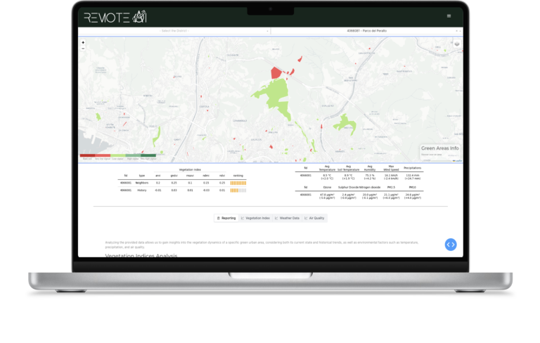
Displays the geographical location of urban green areas and provides details such as name, area, municipality, etc.
Observes changes over time in one or more vegetation indices within the same urban green area.
Compares the values of a single vegetation index across selected urban green areas and analyzes variability compared to other urban green areas.
Inclusion of information regarding certain meteorological and air quality data.
Observe plant health and study their responses to climate shifts, air pollution, sunlight exposure, and other factors in urban green areas using vegetation indices.
Analyze vegetation index variations to assess green space management effectiveness and adjust practices as needed for irrigation, pruning, fertilization, or pest control.
Use vegetation index data for resource allocation, park design, and biodiversity conservation policies in urban planning.
Analyze vegetation index variations to assess green space management effectiveness and adjust practices as needed for irrigation, pruning, fertilization, or pest control.
Comparing indices assesses urban green area management. Contrasting park indices reveals maintenance, irrigation, fertilizer, or waste management differences, guiding improvement.
Differences in nearby green areas' indices may indicate issues like inadequate irrigation, soil degradation, plant diseases, or pollution.
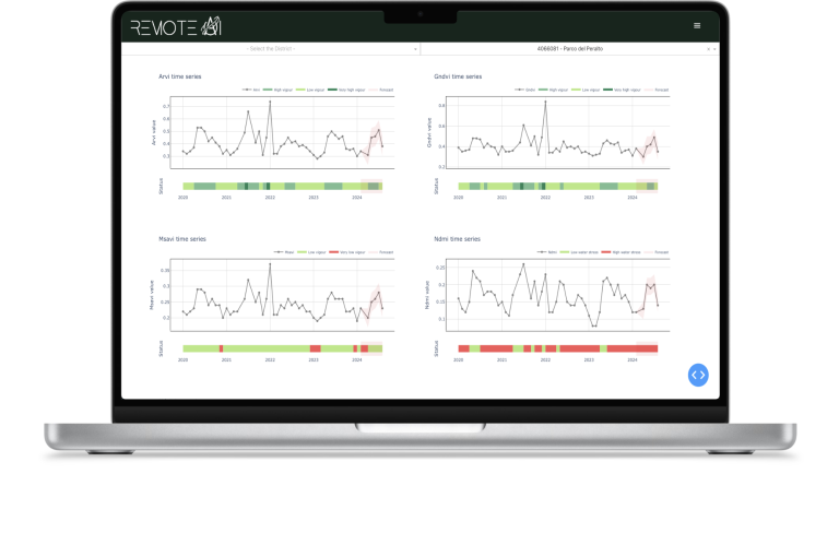
These indices help monitor the health of urban vegetation, detecting stress in parks and green roofs to enable timely care.
NDMI assesses moisture levels, aiding efficient water management in urban green spaces to prevent waste.
Useful in urban planning, MSAVI identifies vegetated vs. non-vegetated areas, highlighting potential locations for new green spaces.
GNDVI tracks photosynthetic activity, useful for managing and selecting plants that optimize carbon dioxide capture, thus improving air quality.
ARVI evaluates how urban pollution affects vegetation, guiding strategies like introducing pollution-resistant plant species or green barriers.
The inclusion of climate and air quality data allows for an examination of the cause-effect relationships between environmental conditions and the health of green areas. For instance, evaluating how climate variations or air pollutants influence plant growth, local biodiversity, or the presence of sensitive species.
By analyzing climate and air quality data alongside green area health indices, vulnerabilities of ecosystems to environmental changes can be identified. This is particularly vital in the context of climate change, enabling prediction and mitigation of negative impacts on natural resources and ecosystems.
Climate and air quality data provide a scientific foundation for green area management decisions. For example, they can inform irrigation strategies, the selection of plant species to use, or actions to improve air quality in the surrounding environment.